DISCLAIMER:
We are pleased to give you online access to mapping information. While we make every effort to produce and publish the most current and accurate information possible, portions of this information may not be current or correct. Neither Spokane County nor any County Department or Entity makes any warranty, express or implied, with regard to the accuracy, reliability, or timeliness of information in this system, and shall not be held liable for losses caused by using this information. Any person or entity that relies on any information obtained from this system, does so at his or her own risk.
Have a question or comment? We want to hear from you! Please get in touch at SCOUT E-mail.
We hope you enjoy using SCOUT!
Topography
Imagery 2024
Imagery with Labels
Street Map
Street Map
Elevation Lines
+-Property Features
Parcels
Parcel Numbers
Site Addresses
Mobile Homes
Condos
+-Sales
Sales - Current Year (blue)
Sales - Last Year (orange)
Sales - Two Years Ago (yellow)
Sales - Three Years Ago (green)
Sales - Four Years Ago (purple)
Sales - Five Years Ago (pink)
+-Plats
Plats, Block Numbers, and Lots
+-Building and Planning Features
Airport Overlay Zones
Municipal Boundaries
Urban Growth Areas
Zoning
Zoning (Spokane)
Comprehensive Plan
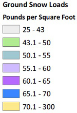
Snow Loads
+-Critical Areas
Flood Hazard Areas
Wetlands
Water Bank Approved Mitigation Area
Watershed Boundaries (WRIA)
Spokane Valley - Rathdrum Prairie Aquifer
+-Elections Features
Precincts
School Director Districts
Legislative Districts